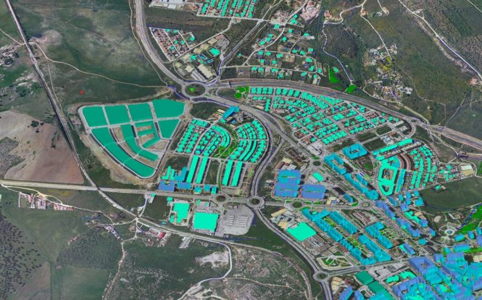
Geographical Information System (GIS) is a technology that enables the collection and effective use of geographic data to support agricultural development and other industries. Unlike traditional paper maps, digital maps offer significantly more value as they can be combined with various data sources for in-depth analysis and graphical representation. GIS software facilitates the integration of large volumes of data by layering different informational sets, which allows for more efficient data management and retrieval. This technology empowers agricultural experts to assist farmers by answering their inquiries and enabling better agricultural planning and development decision-making.
At its core, GIS technology merges data visualization with maps, empowering professionals in various fields—such as city planning, farm management, resource management, and environmental assessments—to make informed decisions. What are GIS maps exactly? GIS maps are dynamic, interactive tools that display spatial data in ways that allow users to analyze geographic patterns and relationships with precision. Unlike traditional mapping methods, GIS maps handle datasets that provide insights into spatial connections and trends, helping users assess social, economic, and environmental variables. This interactive approach leads to reliable and accurate conclusions that guide operations and long-term planning.
A Geographic Information System (GIS) captures, stores, analyzes, and manages data spatially referenced to the Earth’s surface. Also known as geospatial information systems, GIS integrates, stores, edits, analyzes, shares, and displays geographically referenced information. It is a software tool allowing users to conduct interactive queries, edit data, create maps, and present analysis results. GIS technology is increasingly vital in combining map data and remote sensing information to generate models used in real-time applications. GIS applies geographic concepts and systems for diverse uses as a field of study.
GIS finds applications in scientific investigations, resource management, asset management, environmental impact assessments, urban planning, cartography, criminology, history, marketing, and logistics. For example, agricultural planners use GIS to identify the best locations for crop planning by combining data on soil types, topography, and rainfall patterns. The resulting analysis may include overlays of land ownership, infrastructure, transport networks, labor availability, and proximity to market centers, helping to optimize farming decisions and enhance efficiency.
The Various Sectors Utilizing GIS Technology
Urban development
City planners increasingly rely on GIS mapping tools to create environmentally sustainable cities that efficiently manage resources. They study land usage patterns, population density, and infrastructure to make decisions that benefit the community. GIS technology also aids in evaluating impacts to ensure cities expand while keeping their footprints in check.
Farming and Field Supervision
GIS mapping greatly benefits agriculture. It boosts productivity for farmers who rely on it to track crop health and soil quality while monitoring weather patterns for precision farming. GIS technology also helps predict harvest yields and efficiently manage resources like never before in the sector. This results in improved practices that lead to higher food output and sustainable farming practices in the long run.
Monitoring the Environment
Conservationists and environmental organizations use GIS technology to monitor habitats and biodiversity levels. The tool helps track the movement of wildlife, detects the effects of deforestation, and manages conservation areas. By observing environmental changes over time, stakeholders can develop plans to safeguard ecosystems and tackle challenges related to climate change.
Delivery of Goods and People
GIS mapping significantly benefits logistics firms by improving route efficiency and reducing transportation expenses. Logistics firms can allocate resources efficiently and ensure on-time deliveries to their destinations by using real-time information on traffic flow changes and road conditions. GIS technology also enhances customer contentment and operational effectiveness by streamlining operations.
Emergency Services
Geographical information systems (GIS) enhance service delivery in healthcare by analyzing health data. By mapping disease outbreaks and pinpointing the locations of healthcare facilities, authorities can efficiently distribute resources and swiftly address emergencies.
Advantages of Geographic Information Systems in Making Decisions
- Improved Data Representation: One significant benefit of GIS mapping is its knack for turning data into visuals that anyone can understand easily and grasp vital information to make informed decisions swiftly. This is done by revealing spatial relationships and spotting trends and patterns that may be overlooked using conventional data display methods.
- Enhanced Utilization of Resources: Resource management efficiency is an issue in many industries today.GIS technology monitors resources like land, water, and energy to ensure their utilization. Organizations can adopt strategies to reduce waste and enhance resource efficiency by studying consumption trends and predicting needs.
- Evaluating Risks: Mapping using GIS is crucial for effectively planning and evaluating risks in decision-making processes for organizations dealing with disasters or market changes. By visualizing different scenarios and taking proactive steps, they can create backup plans and reduce adverse effects.
Overcoming Obstacles and Looking Ahead
Data Integration
Despite GIS’s advantages, there are still obstacles to ensure data accuracy and integration. Data input errors can result in analyses that could negatively affect decision-making procedures. Progress in data gathering and processing technologies can tackle these hurdles, enhancing the precision and dependability of GIS systems.
Emerging Trends in GIS Technology
The future of GIS technology is filled with exciting possibilities and significant developments. Anticipated progress includes trends such as real-time data analysis, cloud-based digital solutions, and seamless intelligence integration. These advancements are set to elevate the capabilities of GIS, enabling industries to use spatial data more efficiently and enhance decision-making processes across various sectors.
Summary
GIS mapping has dramatically changed how decisions are made in fields by offering a tool for examining spatial data that enables organizations to make well-informed decisions that lead to success. As technology advances further, its impact on improving choices will increase, resulting in more effective and environmentally friendly practices in the future.


