

: Key trends and technologies shaping the future of customer interaction")


The Global Positioning System (GPS) is a satellite-based radio-navigation system was a US military positioning application, made available to the public in 1983 for navigation. In a few decades, GPS technology became an indispensable part of our everyday lives. Now, the GPS devices are everywhere; in our cars, mobile phones, drones, and even on our wristwatches.
GPS is a complex system used to achieve position accuracies ranging from 100 m to a few millimeters, depending on the equipment. It consists of a constellation of 21 satellites equipped with precise atomic clocks, a ground control segment to manage satellite operation, and the users with receivers, which can receive satellite signals and fulfill a broad range of positioning requirements.
Thanks to the explosion of high-end smartphones equipped with Assisted GPS (A-GPS) capabilities. The technology has created a massive market for location-based services, starting from simple “check-in” at restaurants, coffee shops, stores, concerts, and other places or events to maps, contact tracing, and location tracking.
A location-based tracking system uses a smartphone’s GPS to track a person’s location down to a street address. For enterprises that are looking for innovative ways to improve customer relations, it offers numerous opportunities in creating a great customer experience and meeting their expectations with ease. In this post, we present some of the popular location-based technologies, explored as augmentations of GPS technology – often to help overcome GPS limitations.
1. Television synchronization
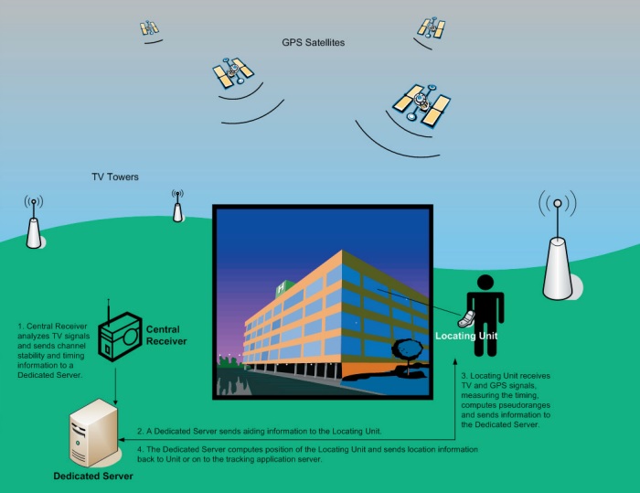
Television synchronization or television-based positioning provides a potential solution to the problem of GPS signal loss in buildings and urban areas with dense concentrations of large buildings. The technique is used to position devices like personal digital assistants, laptops, asset-tracking devices for emergency response personnel. Since the standard television synchronization signals typically have a power advantage over GPS of more than 40 dB and a bandwidth of roughly 6 MHz, it is substantially superior for triangulating lateral position. Unlike GPS, the synch signals are not affected by transmitter Doppler, ionospheric propagation delays, or data that is modulated onto the signals.
Benefits
- It is possible to monitor the location in urban canyons, inside a building, or when someone attempts to “hide” the locating unit (e.g., in the trunk of a car).
- Properly implemented signal reception and analysis software can reduce alerts like “No GPS” and reduce the workload of human monitors.
2. Wi-Fi Positioning
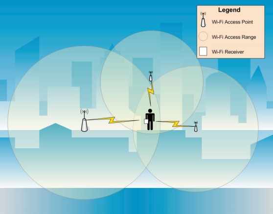
Wi-Fi Positioning System (WPS) is a geolocation system that relies on Wi-Fi to locate compatible devices and users. If your device has both GPS and Wi-Fi, it can indeed send information about a network’s location back to a GPS service. Companies like Google, Apple, and Microsoft use GPS to identify Wi-Fi networks, which can then be used to find someone’s device as it relates to nearby Wi-Fi. Even in the absence of traditional GPS tracking systems, it is possible to track the location of a user or device, using Wi-Fi access point signals and the use of Wi-Fi. For instance, hardware or software which is found in most modern laptops or PDA devices is capable of detecting the presence of wireless networks and publicly accessible information.
Benefits
- It is very useful in urban environments, where there are many wireless networks broadcasting within the same area.
- Unlike GPS technology, Wi-Fi works indoors quite well. This could help to overcome the “No GPS” signal loss problem.
- Many businesses can use this technology to enhance customer engagement.
3. Radio Frequency Identification (RFID)
Radio Frequency Identification (RFID) uses electromagnetic fields to transmit data from an RFID tag to a reader. RFID can provide accurate, real-time tracking data for fixed and mobile assets, starting from office equipment, factory tools, cars, etc. We have two types of RFID tags: active and passive. The passive tag does not contain a battery. It gets power from the reader. When a passive RFID tag encounters radio waves from the reader, the coiled antenna within the tag forms a magnetic field, energizing the circuits in the tag. On the other hand, an active RFID tag has a battery, Bluetooth chip, and a single antenna.
Benefits
- RFID tags are very inexpensive to manufacture
- Unlike GPS technology, RFID technology works well indoors.
- Increase asset visibility.
- Improve employee productivity.
- Mitigate risk, theft, and loss.
4. Microchip implants
Microchip implants are devices like RFID microchip, which is a tiny, two-way radio, roughly the size of a grain of rice, capable of transmitting stored digital information when it passes through a receiver like a security checkpoint. Microchip implants are embedded inside dogs, cats, chimps, and humans, acting as unique lifetime identifiers. The implant typically contains a unique 16-digit identification number that can be linked to the information contained in a database, such as personal identification, law enforcement, medical history, medications, allergies, and contact information. This technology makes it possible to verify and confirm the identity of a person instantly.
Benefits
- Small enough to be implanted without invasive surgery
- Cause no noticeable change in a recipient’s appearance.
- Surprisingly inexpensive and can last long
- Easy to access information
- Does not interfere with other electronic devices
- It does not contain a battery, nor does it need to be charged.
- Little or no maintenance after implantation.
5. Biometric recognition
Biometrics is an automated recognition of individuals based on unique or nearly unique physiological characteristics like fingerprints, iris patterns, facial characteristics, voice patterns, and handwriting. With recent advancements in areas like digital imaging, pattern recognition, audio analysis, and micro-electronics, biometrics is at the forefront as a popular and well-funded research area. Biometric systems are used increasingly to recognize individuals and regulate access to physical spaces, information, services, and other rights or benefits, including the ability to cross international borders.
Benefits
- Improve the convenience and efficiency of routine security checks, transactions, etc.
- Reduce fraud and enhance public safety and national security
6. Satellite imaging
When it comes to location tracking, the idea behind satellite imaging could resemble the favorite themes of science fiction and high-tech thrillers like “spy satellites.” These movies highlight this technology which postulates extremely high-resolution cameras operating from a spacecraft that can perform such magic as allowing the observer to read a wristwatch dial or a vehicle license plate, or to distinguish the facial features of a single individual. No one knows the true resolution of today’s reconnaissance satellites. Still, the fact is commercial imaging satellites can obtain at least generic identification of objects or people like a registered sex offender, or a paroled drug dealer. Satellite imaging is now part of the new data revolution powered by remote sensing technologies – like drones, aerial photographs, and satellite sensors.
Benefits
- Quickly and inexpensively identify specific locations and record movement paths.
- Such tools are readily available and are easy to use.
7. Dead Reckoning (DR)
Dead reckoning technology aims to address the problem of GPS signal loss both indoors and as a result of travel over long distances in enclosed vehicles (e.g., planes, trains, boats) or terrain (e.g., mountains, canyons) where natural obstacles mask GPS signals. It enables us to keep high accuracy positioning by using information from various sensors (gyro sensor, accelerometer, speed pulse, etc.) to calculate the current position, even when GPS/GNSS only positioning is difficult or impossible. It is widely utilized in automotive navigation systems.
Benefits
- Location tracking can be achieved independently of the presence of a continuous GPS signal.
- Provide a more constant set of location data
- No dead signals when traveling into parking garages or tunnels.
- Less confusion on highways with multiple lanes and overpasses.
- Less time wasted on faulty navigation.


 batteries safely")
